Technology
FloodCams
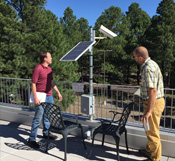 The FloodCams are located at flood-prone areas, such as a storm drain, intersection, or stormwater basin. A white and red striped painted gage is placed at the location to provide a scale. We explored multiple mounted camera technologies. The resulting cameras are able to operate 24-7 on a small solar power system, can be placed on any sturdy pole or structure in about an hour, and reliably relay data (images, power system status, local temperature) back to our server. We have implemented 18 FloodCams across Phoenix, Arizona and Flagstaff, Arizona.
Gaging
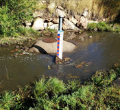 We are installing gage points in each city to work with and independently of the FloodCams. These gage points will provide targets for (and serve as reminders to) community members to snap and upload flooding images using the mobile app (in development, see below). We are currently able to accurately determine water level based on a fixed camera image and are now working to refine our approach to function reliably in anomalous conditions, e.g., where lighting is not optimal, at nighttime, or when various gauging points are obscured by persons or vehicles.
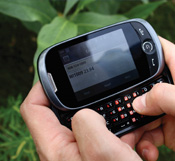
Mobile Hydrology
The Mobile Hydrology app will not only provide a crowd-sourced stream of primary flood stage data, imagery, and floodwater presence/absence data, but will also communicate visualizations of rainfall and flood histories to users, encourage users to collect data during heavy precipitation events, and notify users when floods are likely to occur or are currently occurring near their immediate location.
CrowdHydrology
 We are integrating information from the CrowdHydrology platform to have the capacity to receive and process flooding data from a variety of existing networks across 8 states. CrowdHydrology is a citizen science-based observation network that collects spatially distributed measurements of stream stage in ungauged watersheds. Users text in water levels at existing gauge plates. The CrowdHydrology integration serves as an important step for integrating flooding information streams from existing systems.
Social Media
We are extracting data from social media streams, often called social media mining, which has become an increasingly effective data stream of real-time information. We are extracting two valuable pieces of information from such streams. First, posts to platforms like Twitter and Facebook spike when and where there is something “exciting” to share. Filtering Twitter and Facebook streams by locality, then mining them for keywords and hashtags (e.g., flooding, overflowing, under water) can help highlight areas of particular interest within a local flood stage model. Second, users often post images in addition to their comments which can be extracted and analyzed for water level information.
Urban Hydrology Forecasting
 We have developed draft models of the urban hydrology and hydraulics for two pilot areas in Phoenix, AZ and one larger pilot area in Flagstaff, AZ. These models use the open-source EPA Stormwater Management Model (SWMM) software. The models are developed using the best available topographic, infrastructure and land use data in each city. In parallel to the model setup, we have also collected rainfall data at these locations, which are needed for the simulations.
Community Partners Interface
To complement this project website, we have developed a community information website to help both municipal collaborators and citizens better understand the FloodAware project aims and approach. It also helps to engage them in the data gathering and flood monitoring aspects. Users may click on each a monitored location to view camera information, imagery statistics, a hydrograph that shows water level detected at the location over time, and the last image uploaded. If you are interested in becoming a user, please see the Login page.
FloodAware Mobile Application
The FloodAware Mobile Application is in development. The goal of the mobile application is to allow community partners (like you!) to engage with reporting flooded areas and receive flood alerts.
To learn more about these efforts, check out our educational video modules on the Outreach page.